Facts about Northern Territory Australia
Area:1,349,130 sq kms (520,902 sq miles)
State Population:197,700
Capital: Darwin
Population: 144,00
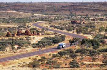
The Northern Territory makes up nearly one-sixth of Australia and geographically most closely resembles the popular image of the Great Australian Outback.
The north or Top End, centred on the capital,
Darwin, is tropical with rich vegetation and a varied coastline.
251km east of Darwin is World Heritage-listed Kakadu National
Park (the third largest National Park in the world and about
half the size of Switzerland), an area of vast flood plains
and rocky escarpments steeped in natural and cultural heritage
and home to Aborigines for at least 40,000 years. Katherine
is 314km south of Darwin and just beyond that is Nitmiluk (Katherine
Gorge) National Park, a striking system of 13 gorges towering
up to 60 metres high.
The southern part of the Territory is centred on Alice Springs,
which is virtually the centre of Australia and the starting
point to explore many of the Red Centre's highlights including
Uluru (Ayers Rock), which is located about 465kms to
the south-west.
Other of the Red Centre's natural and geological wonders include Kata Tjuta (the Olgas), King's Canyon, the Western MacDonnell Ranges and the Devil's Marbles.
Some areas that we visit have great significance
to the local Aborigines and as such are culturally sensitive.
Access to these areas (which includes the Uluru (Ayers Rock)
climb) may be restricted for cultural reasons for unspecified
times and with little prior notice. We reserve the right to
amend our itineraries or visit alternative areas in these circumstances
and no refunds will be given.
Red Centre:
Uluru-Kata Tjuta Aboriginal Cultural Centre: in keeping with
the park's importance to indigenous people, major emphasis is
placed on helping visitors understand Aboriginal traditions
and lifestyle. The Cultural Centre houses the park's information
services with displays presenting the sights and sounds of Tjukurpa
(creation stories and laws) and the local culture.
Top End:
Warradjan Aboriginal Cultural Centre: the centre's circular
design represents a warradjan (pig-nosed turtle). As well as
providing detailed information about Aboriginal culture in Kakadu,
there is also a video room and a gallery that sells Aboriginal
arts and crafts plus books and cards.
Aboriginal Rock Art:amazing examples of rock
art dating back an estimated 40,000 years can be seen throughout
Kakadu but most notably at Ubirr and Nourlangie.
Red Centre:
You may see kangaroos, emus, wild camels, goannas, thorny devils
and more.
Top End:
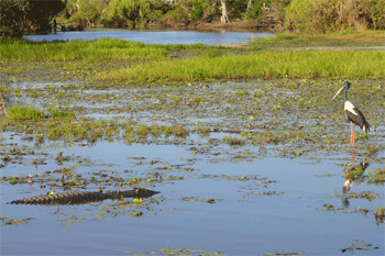
You may see wallabies, salt and fresh water crocodiles, buffalo,
frill-neck lizards, wild pigs and a huge variety of bird life
including wedge-tailed and sea eagles, jabiru and herons.
Seasonality of the Top End
Located in the Arid Tropical region of Northern Australia means
that you enjoy beautiful weather for the majority of the year.
The Top End experiences 2 distinct seasons as outlined below.
|
Average Minimum |
Average Maximum | Description | |
| Tropical Winter | 21.5°C | 31.5°C | Unlike most southern capitals which usually experience cool temperatures at this time of the year, the Top End enjoys blue skies, warm dry days and cool nights...perfect for outdoor adventures and touring. |
| Tropical Summer | 24.6°C | 32.2°C | Spectacular electrical storms, sun showers and warm, humid weather are the characteristics. The waterfalls are in full flow, flocks of birds spread across the wetlands, and a rich lush green becomes the dominant colour scheme |
Due to rainfall and distinct seasonality, access into parts
of Kakadu National Park will be restricted from Dec-Apr. At
this time of year, some travellers may feel that Kakadu is a
harder adventure than the soft nature of our other tours.
Interest
Adelaide River township: approximately 110kms
south of Darwin along the Stuart Highway you will find the World
War II Cemetery.
Alice Springs: Alice Springs is the famous geographical
centre of Australia. This town is situated on the Stuart Highway
and is a place where the traditional Arrernte Aboriginal owners
have lived for about 20000 years. About 29000 people live in the
town nowadays. Alice Springs is unique insofar as the town is
situated 'in the middle of nowhere' but the atmosphere there is
really warm, the nightlife is just amazing, and the attractions
nearby are numerous.
Annaburroo: a saltwater, crocodile free swimming
billabong.
Barramundi Gorge (Maguk): one of the few permanent
waterfalls in Kakadu, it has cut its path through the ancient
sandstone creating an oasis where we can swim.
Barrow creek pub: this pub is a typical stopover
point on the Stuart Highway and is located about 280 kilometres
north of Alice Springs.
Buley Rockhole: with Wangi Falls this series
of small waterfalls is certainly the most popular and beautiful
swimming spot in the Litchfield National Park.
Carr Boyd ranges: located south of Kununurra
Carr Boyd Range offers beautiful sceneries with deep gorges, nice
waterfalls and pretty fern pools. The wildlife is also abundant
there.
Coober Pedy: is the opal capital of the world,
producing 95% of the world's opals and attracts a special breed
of people. There are 41 different nationalities living in a population
of just over 4000 people. 80% of them live underground to avoid
the heat. There are underground shops, churches, hostels and hotels.
We accommodate our guests in an underground bunkhouse, but also
offer the opportunity to upgrade accommodation to a 4 star hotel
for those who want to break the journey. Passengers will be taken
on a mine tour and given the opportunity to ânoodleâ for their
own opals.
Curtin Springs Station: a working cattle station
of some 4000 square kms, on which is located Mt Connor.
Cycad Gorge at Palm Valley: clumps of tall, slender
palms lending a tropical atmosphere to their barren setting. These
pre-historic palms are leftovers from much wetter times in Central
Australia.
Daly Waters: the famous pub at Daly Waters, the
oldest in the Northern Territory, is situated 588kms south of
Darwin and also acts as a bank, post office and police station.
It dates back more than a hundred years and was originally built
for the pioneer drovers on the long cattle drives through this
part of the Outback.
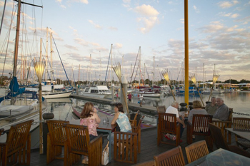
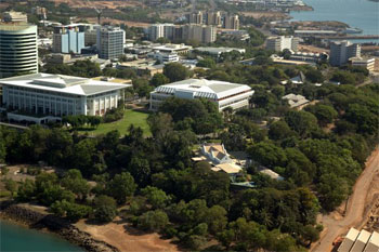
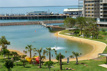
Darwin: This is the most popular town and also
the territorial capital of the Northern Territory. It is a city
of about 110000 inhabitants with a large proportion of Aboriginal
people, which justify the fact that the town is sometimes called
'the multicultural capital of Australia'.
Devils Marbles: massive red granite boulders
balancing precariously on top of each other located some 100kms
south of Tennant Creek.
Edith Falls: located about 60 kilometres north
of Katherine, Edith Falls is a series of superb waterfalls and
beautiful pools cascading into a lake. An ideal place for swimmersâ¦
Finke River: this River is the main river in
Central Australia and also one of the oldest rivers in the world.
Florence Falls: situated in the Litchfield national
park near the rainforest, it is an impressive and beautiful double
waterfall dropping down into a clear rock pool where people can
enjoy a swim.
Fogg Dam: a conservation reserve about 60kms
from Darwin, where permanent wetlands are alive with bird and
wildlife and water lilies. Anbangbang Billabong - a small and
picturesque seasonal billabong that's home to a variety of bird-life.
Glen Helen Gorge: situated about 130 kilometres
from Alice Springs Glen Helen gorge is one of the six waterholes
along the Finke River and is a beautiful spot for swimming and
enjoying what nature has to offer.
Gosse Bluff: a spectacular remnant of a huge
meteor crater believed to be about 130 million years old.
Gunlom Falls: a large waterfall situated in the
southern end of Kakadu National Park, it offers scenic swimming
holes etched into the Escarpment by the relentless action of erosion.
The climb to the top is rewarded with fantastic views over the
park.
Gregory National Park: situated about 350 kilometres
from Darwin, this National Park is the second-largest in the Northern
Territory. It is a mixture of beautiful sandstones, escarpments
and gorges.
Jim Jim & Twin Falls: spectacular waterfalls
accessible only during the Dry Season (May to November) by 4WD
vehicles. Swimming ability is a must (1km return paddle to the
base of Twin Falls)
Kakadu National Park: this National Park situated
about 250 kilometres from Darwin is an Australian icon and one
of the most visited National Parks in Australia. It is renowned
for its diverse environment from amazing waterfalls and to beautiful
Aboriginal rock art. Between Alligators, birds and kangaroos,
the wildlife is rich and numerous.
Kata Tjuta (the Olgas): this 'place of many heads'
has 36 domes that make up a site of even greater cultural significance
to the Aborigines than Uluru. There are two permitted walks in
Kata Tjuta (no climbing is allowed as requested by the traditional
owners), the Mt Olga pass, which is around 3km return and the
Valley of the Winds which is approx 8km return.
Katherine Gorge: actually consisting of 13 gorges
which are best viewed from the air, you can canoe or cruise around
the first few gorges appreciating the striking landscape.
Kings Canyon (Watarrka): is a canyon almost 275
metres deep. A 6-8km walk around the canyon gives spectacular
views of the surrounding desert and special features such as the
'Lost City', the 'Amphitheatre' and the 'Garden of Eden'.
Litchfield national park: situated about 130
kilometres from Darwin, this National Park is a mixture of dense
tropical rainforest, eucalyptus, and magnetic termite mounds.
Mamukala Wetlands: Mamukala Wetlands is one of
the most visited places in Kakadu National Park, and an ideal
place to see thousands of magpie geese and lots of other birds.
Mary River Wetlands: is the largest system of
its kind in the Northern Territory. It boasts the highest concentration
of salt-water crocodiles in the Southern Hemisphere, as well as
an amazing profusion of other wildlife. ATA offer a private boat
cruise on the wetlands for our passengers. Our boats seat only
24 passengers in contrast to the 50 seat boats operating on other
cruises such as Yellow Waters and the Adelaide River.
Mataranka: this is a small town located along
the Stuart Highway about 100 kilometres south of Katherine.
Mataranka thermal springs: these thermal springs
are situated underground in the Elsey National Park and are incredibly
clear and hot.
Mereenie 4WD Track/Loop Road: completed in 1994,
this 4WD road loops around the western edge of the MacDonnell
Ranges linking Kings Canyon with Alice Springs.
Motorcar falls: with its amazing 25 metres waterfall
dropping down into a pretty rock pool, Motorcar Falls is one of
the best wet season areas in Kakadu National Park.
Mt Connor: higher than Uluru and often mistaken
for it, we pass this flat topped monolith on the way to Yulara.
Nourlangie Rock: located approximately 330km
east of Darwin in the heart of Kakadu National Park, another ancient
rock art site famous for its dynamic display of art and panoramic
views of the Escarpment country.
Nungulawar art site: a site which allows people
to see aboriginal art, paintings, dreaming stories etc.
Ormiston gorge: this gorge has a beautiful waterhole
surrounded by nice tropical plants and flowers.
Point Stuart Wilderness Lodge: this Lodge, just
30kms outside Kakadu National Park, offers travellers the opportunity
to explore the pristine Mary River Wetlands renowned for its abundance
of wildlife, beautiful billabongs, cool rainforests and excellent
barramundi fishing. The Lodge has a range of accommodation from
air-conditioned units with en-suite facilities to backpacker dorms
and camping. It also has a swimming pool and fully licensed bar
and bistro.
Robin falls: located about 17 kilometres south
of Adelaide River, Robin Falls is a beautiful little waterfall.
Small gorge: this gorge is, as its name says,
a pretty small gorge, however this is a really beautiful double
fall with a nice clear pool.
Tennant Creek: about 986 kms south of Darwin
was the centre of Australia's last gold rush in 1930. Passengers
enjoy a gold mine tour here on our trips between Alice and Darwin.
Ti Tree: Ti tree is a small service town and
supply point on the Stuart Highway, and is located about 190 kilometres
from Alice Springs. Lots of Aboriginal people (about 1300) still
live there.
Timber creek: this small town of about 600 inhabitants
is situated about 290 kilometres from Katherine. It lies on Victoria
Highway which connects Australiaâs top end and the Kimberley
region in Western Australia.
Tolmer falls: this long and narrow waterfall
is one of the highest and most spectacular in the Litchfield National
Park.
Tropic of Capricorn: This is one of the five
main circles of latitude on Earth maps. It passes about 30 kilometres
north of Alice Springs.
Ubirr Rock: approximately 280km east of Darwin,
Ubirr has been home to Aborigines for an estimated 25,000 years.
They have recorded and documented the changing landscapes and
social occurrences in the rocks at this site. The art is endemic
to this region.
Uluru (Ayers Rock): the second largest
Monolith in the world and centre of the sacred heart of Australia,
it is of deep cultural significance to local Aborigines. Though
the traditional owners would prefer if they didnât, visitors
can still climb it. Our guides give clients the information to
make an informed decision and then the choice is up to the individual
(the climb is 1.6km from base to top and people with heart conditions
or breathing difficulties should not attempt it). Climbing is
not permitted if the Rangers consider it unsafe due to extreme
temperatures, wind or rain. Photography is limited in some sites
because of their significance.
Uluru-Kata Tjuta Aboriginal Cultural Centre:
In keeping with the park's importance to indigenous people, major
emphasis is placed on helping visitors understand Aboriginal traditions
and lifestyle. The Cultural Centre houses the parkâs information
services with displays presenting the sights and sounds of Tjukurpa
(creation stories and laws) and the local culture.
Valley of the Winds (Kata Tjuta): this spectacular
hike, varying in length from (approx) 6-8km depending on the trip
chosen, winds through some of the 36 weathered domes. NB: The
trail is closed when temperatures rise above 36°C.
Wangi falls: situated in the Litchfield National
Park, Wangi Falls is a renowned area for swimming and picnicking.
Warradjan Aboriginal Cultural Centre: The centre's
circular design represents a warradjan (pig-nosed turtle). As
well as providing detailed information about Aboriginal culture
in Kakadu, there is also a video room and a gallery that sells
Aboriginal arts and crafts plus books and cards.
Western MacDonnell Ranges: form an imposing red
barrier from east to west for 400kms across the vast central Australian
plain with Alice Springs situated in the centre. The Ranges stretch
160kms west of Alice Springs offering spectacular landscapes and
gorges.
-

4wd Rooftop Tent Camper
4wd Camper hire from Darwin -
Campervan hire Darwin
Travel in comfort in a campervan -